While Henry Cowell Redwoods State Park is a favorite destination for nature lovers, the Fall Creek Unit offers a more tranquil alternative for those seeking a less crowded experience. This 10-mile loop takes you through diverse landscapes of second-growth redwood forests, historic landmarks, and evidence of the forest’s resilience, all while avoiding the busier main trails of the park.
On a cool Sunday morning, I arrived at the Felton Empire parking lot for a hike through the Fall Creek Unit of Henry Cowell Redwoods State Park. This quieter section of the park, located just a quarter-mile from the town of Felton, offers a peaceful escape from the busier main trails. With 2,390 acres and nearly 20 miles of trails, the Fall Creek Unit takes hikers through second-growth redwood forests, past historic remnants of industry, and into areas shaped by wildfire and natural resilience. No dogs or bikes are allowed in Fall Creek Unit.
Parking for Fall Creek Unit
The Felton Empire parking lot is the primary access point to the Fall Creek Unit. Parking is free, but the lot is small, with about 20 marked spaces and room for a few additional cars along the edges. By 10 a.m. on a Sunday, I was lucky to grab one of the last designated spots. If you’re planning to hike on weekends, arriving early is the best way to avoid parking frustration.
There are two access points from the Felton Empire parking lot that both lead you on to Bennett Creek Trail that connects to Fall Creek Trail. There is a large map and information board. I took the trail on the left that takes you down to Fall Creek. Hiking the trail along Fall Creek is both an intensely visual and auditory experience.
Hiking Fall Creek Trail
If you find the sound of rushing water to be soothing, this is a hike for you. The trail closely follows the Fall Creek through a shaded grove of second-growth redwoods. The dense canopy creates a tranquil, shaded atmosphere, making this part of the hike particularly refreshing, even on warmer days.
The creek is a highlight throughout this section. Its character changes frequently, alternating between shallow, rushing streams and tranquil pools that reflect the sunlight filtering through the trees. In some areas, the trail hugs the creek closely, and there are small trails that lead towards the banks of the creek.

The lower section of the Fall Creek Trail is not only defined by its towering redwoods and the soothing sound of the creek but also by the lush, vibrant ferns that carpet the forest floor. These ferns thrive in the cool, damp environment, creating a soft, green underlayer that contrasts beautifully with the dark, towering trunks of the redwoods.
The trail itself is a narrow compacted dirt path. Fallen trees are visible everywhere in this section of the second-growth redwood forest. Some trunks jut into or lay across the trail, so be prepared to have to duck under or climb over trees.

Crossing over a short bridge, hikers can continue on Fall Creek Trail to the right. I opted to bear left to take South Fork Trail which winds its way along this short branch of Fall Creek.
South Fork Trail starts the ascent up into Fall Creek Unit. The trail has some steep sections and some very uneven terrain. This one uphill trail section was embedded with large rocks.

The reward for hiking up South Fork Trail is a view of the remnants of the IXL lime kilns. Limestone exposed by the Ben Lomond Fault was processed here between 1874 and 1919. Heating limestone in these kilns for several days produced lime, a key ingredient in mortar and plaster that was in high demand during California’s construction boom.
Not much is still visible from at this spot of the lime kilns but there is an information placard where hikers can read a little bit about the lime kilns.

A short hike further up from the lime kiln site along the South Fork Trail leads to the Powder Magazine, a small stone structure used during the 19th century to store blasting powder. This sturdy building, constructed from limestone blocks, was an essential part of the lime production process, as blasting powder was needed to extract limestone from the nearby quarries. The Powder Magazine’s thick walls and isolated location ensured safety in case of accidental explosions.

Cape Horn Trail
Continuing past the Powder Magazine site, South Fork Trail ends at a junction that includes access to the Cape Horn Trail. Cape Horn Trail begins a steeper ascent into the higher elevations of the redwood forest, offering new perspectives on the landscape.
The ground is noticeably drier along this trail and the sounds of the creek start to fade away. The trees are thinner and more direct sunlight reaches down into the forest floor at this elevation.
The trail here is wider than the narrow single-track Fall Creek and South Fork Trails. A fallen tree blocked the trail but I was able to climb through the jumbled branches to the other side.

Reconnecting to Fall Creek Trail
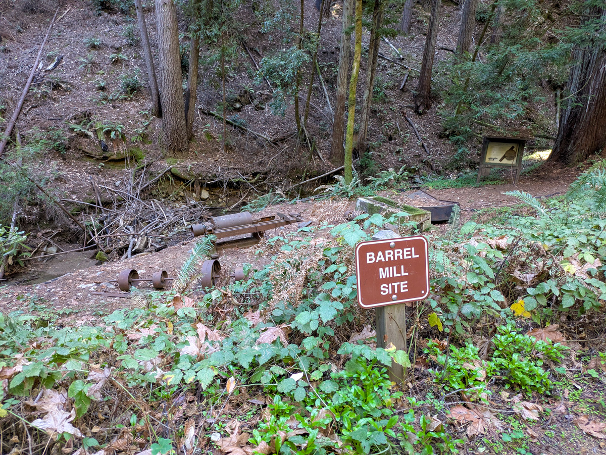
Cape Horn Trail crosses over to connect back up with Fall Creek Trail. This trail continues across Fall Creek up towards Barrel Mill. The barrel mill site is where barrels were once crafted to transport lime. Rusting pieces of equipment, including a stave machine used to shape barrel staves, remain scattered across the site.
Crossing Fall Creek again
A short hike past the Barrel Mill site is another crossing of Fall Creek. Unlike the previous crossing, this one has no planks. So, step carefully, and test the stability of the improvised pile of logs in order to cross without having to step into the water of the creek.

Big Ben Trail

Fall Creek Trail continues to gain in elevation where it connects with Big Ben Trail. I began the climb up Big Ben Trail, one of the more physically demanding sections of the hike. The trail gains elevation steadily, offering a stark contrast to the flat, shaded lower trail. Evidence of the CZU Lightning Complex Fire is prominent here. Charred tree trunks and fallen snags are scattered throughout the landscape, serving as reminders of the fire’s destructive force.
Despite the damage, signs of recovery are everywhere. New growth is pushing through the soil, and young redwoods are reclaiming their place in the forest. The ascent brought new perspectives on the forest, with glimpses of ridges through breaks in the trees. This trail felt less traveled, with sections where overgrowth makes the path feel closed in. Up here, I hiked for almost an hour without running across another hiker.

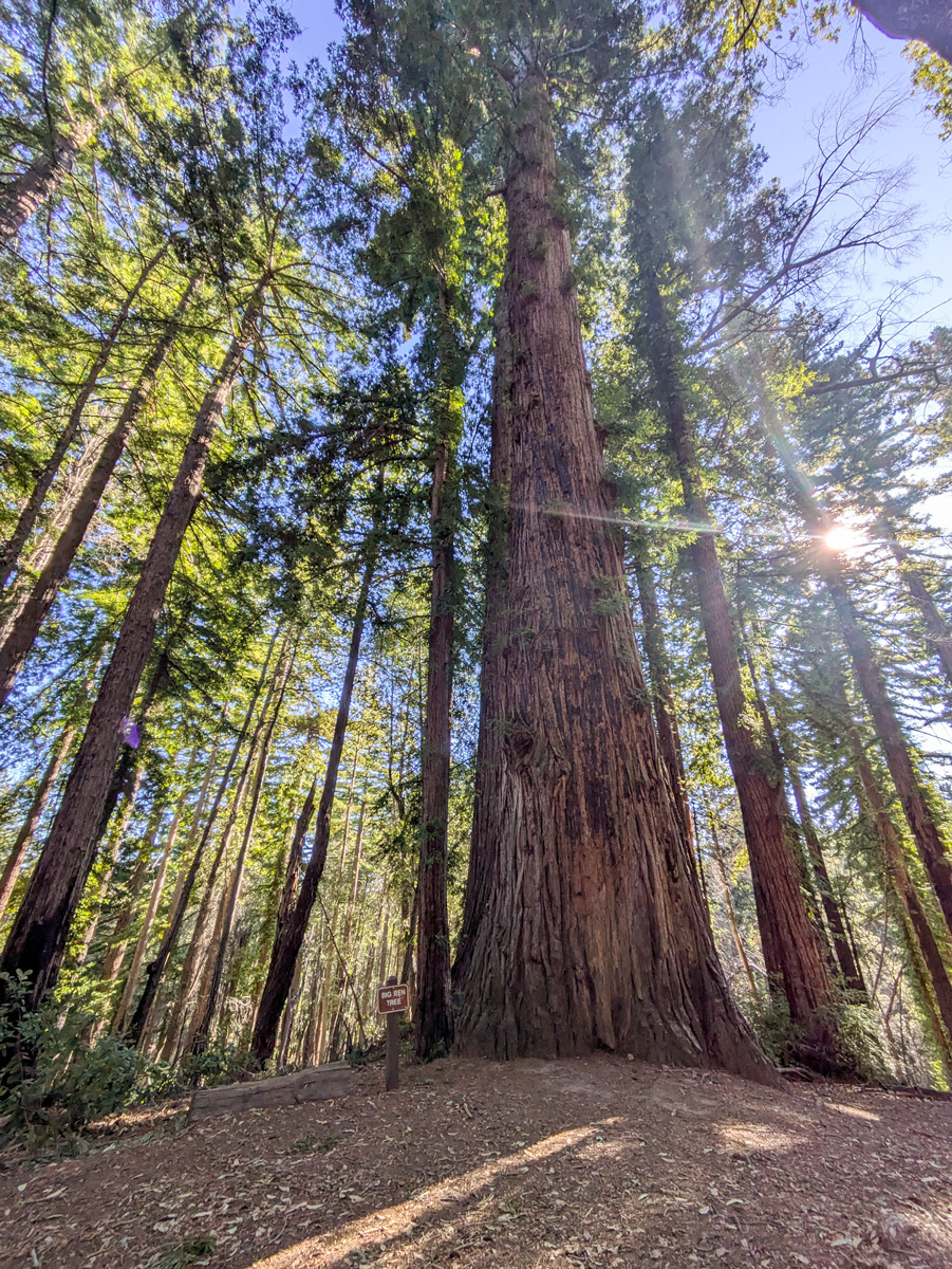
Big Ben Tree
Big Ben is located at the junction of Big Ben Trail and Lost Empire Trail. Big Ben is a medium-sized redwood tree that stands out as the largest tree in the cluster of second-growth redwoods in the area.
Lost Empire Trail
After visiting Big Ben Tree, I continued onto Lost Empire Trail. This trail takes hikers to even higher elevations where the forest canopy begins to open, letting more sunlight illuminate the trail.
Birds in this forest shy away from humans. Banded pigeons flapped noisily between branches, while woodpeckers drummed on snags in search of insects. Dark-eyed juncos along the trail were the only birds bold enough to remain along the trail as I hiked through.

Once I hiked past the ridge area of Lost Empire Trail, I began the descent back down towards the Felton Empire parking lot. The return descent took well over an hour. The steepness of the backside of Lost Empire trail has led to deep erosion in the trails. There are some temporary signs warning about the trail being “undermined” so hikers should take care to avoid tripping and injuring themselves along the uneven trail.

Returning to Fall Creek Trail
The loop eventually brought me back to Cape Horn Trail, which reconnected with Fall Creek Trail and led me to the Benett Creek Trail access points near the parking lot. Descending to the lower trail was a calming transition, with the creek’s gentle bubbling once again becoming a constant companion. The shaded redwood groves provided a cool and quiet end to the hike.
What to know before you go
- Parking: The Felton Empire parking lot offers free parking with two access points to Benett Creek Trail, which leads to Fall Creek Trail. Arrive early, as spaces fill quickly on weekends.
- Distance and difficulty: This 10-mile loop involves moderate to steep elevation changes and takes about 4–5 hours to complete, depending on your hiking speed and experience. Tree fall across several points of the trail system adds an additional level of complexity to the hike.
- Trail conditions: Expect to navigate narrow paths, uneven terrain, and frequent treefall.
- What to bring: Sturdy hiking shoes, water, snacks, and a map or GPS-based app like Strava for navigation. Binoculars are useful for spotting wildlife such as woodpeckers and Western gray squirrels.
- Regulations: Fall Creek is day use only. Dogs, bicycles, camping, fires, and smoking are not allowed in the Fall Creek Unit. Horses are allowed only on designated trails.